It will likely take you the whole day to get to Little Corn Island, a small speck of lush jungle meets hidden beaches, with just footpaths and boats to get around. The island is reachable only by boat from nearby Big Corn Island, itself accessible by ferry or flight from the mainland. Often the more difficult to reach places on this increasingly crowded planet are among the more alluring, and this is no exception.

Arriving to Little Corn Island
After 3 flights, a short group taxi, and a bumpy 45 minute boat ride run by some of the friendliest people around, all our weariness dissipated as we disembarked on Little Corn and walked a hundred metres or so to our lodging. Dropping off our bags, we ran out to the nearby beach to take a dip in the sea alongside the setting sun. Afterwards, we feasted on local seafood and pasta at the Italian-run Cafe Desideri, located among the cluster of eateries and sundry shops in town. By 10pm, every spot had closed, and most of the island was asleep amidst a calmness that is increasingly hard to find these days. No cars or motorbikes zoomed past in the night. Even a bicycle was a rare occurrence on an island on which everyone walks. And electricity on the island runs only at night.

Ferry arriving to Little Corn Island
We woke up early and excited for one of the purposes of our trip: scuba diving! Little Corn is surrounded by a shallow reef that is home to an abundance of sea creatures: octopus, turtles, lobster, crabs, shrimp, rays, nurse sharks, and more. We dove with Las Palmeras Dive Center, which is conveniently located and well-run. They typically offer two dives in the morning and a night dive departing just before sunset. The night dives were some of the best I’d experienced anywhere. We were treated to octopus sightings and flashes of bioluminescence when the moonlight disappeared behind some clouds in the sky above us, leaving us in darkness and better able to see the flashes of light all around.
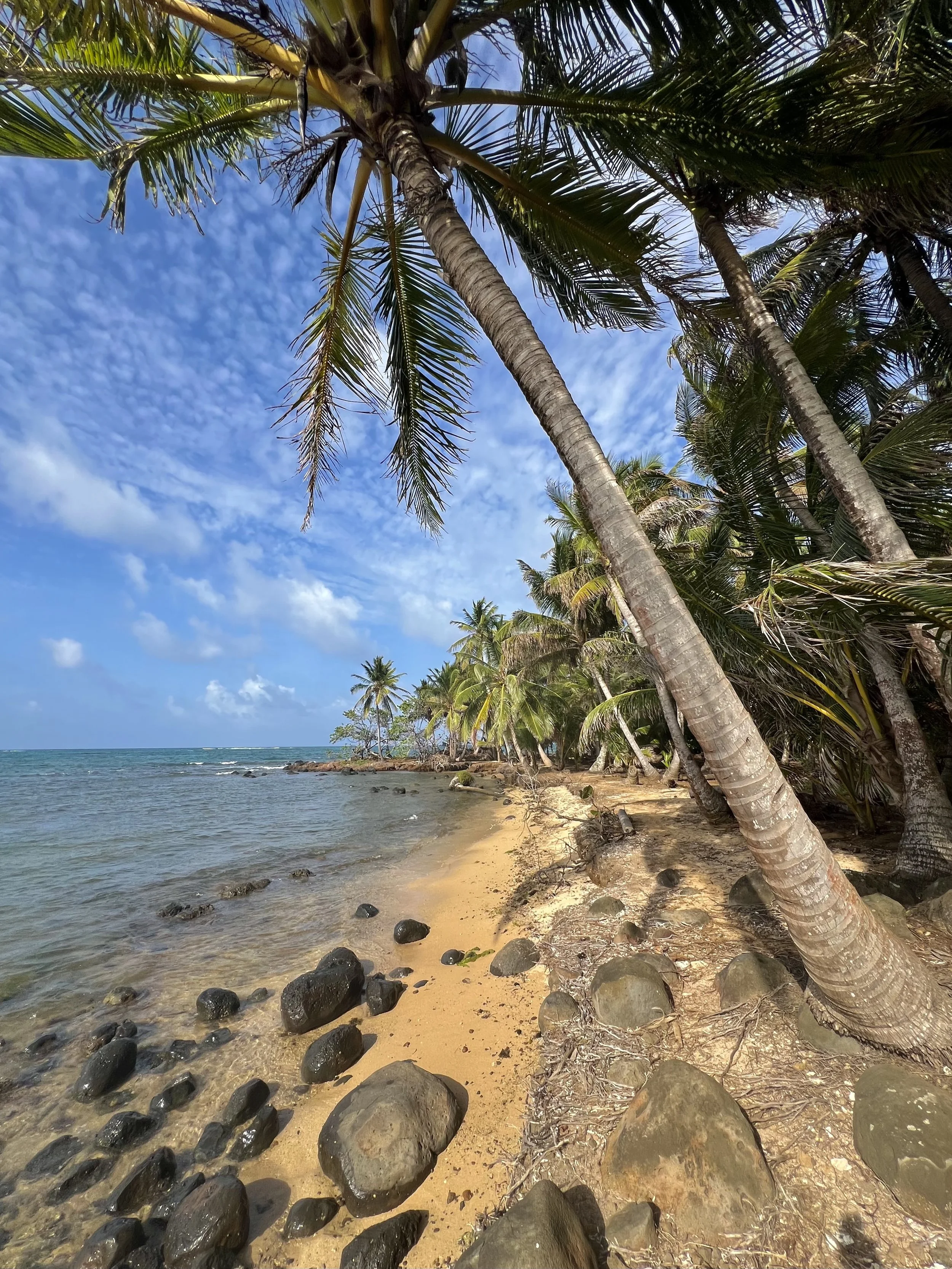
Beach cove along the northern coast of Little Corn Island, Nicaragua
Dirt trails run across the island through tropical forest filled with mango and other seasonal fruit, leading to small beach coves framed by palm trees. Worth a visit are the northern beaches (reachable via a 20 minute walk from town past the local stadium, or via a short boat ride), featuring gentle waves great for swimming, a fish shack, and an upscale restaurant called Erizo (part of the Yemaya Reefs resort, the only one on the island). We savored the rondon, a traditional island seafood stew with root vegetables simmered in a coconut milk broth; a cucumber and kiwi salad with calala dressing; palm hearts and fruit ceviche.

Walking path on Little Corn Island

Yemaya Reef, Little Corn
A few coves to the east is Derek’s Place, another lodging option with hammocks and a laid back vibe. Tracking back inland to then join a path leading to the windward side of the island, you’ll reach Little Corn Beach and Bungalow and its restaurant, the Turned Turtle, where you can eat delicious local specialties with your feet in the sand while watching the waves roll in (note: open for breakfast and lunch only). On our last evening on the island, we had dinner by the southern edge of town at the casual, family-run Melissa’s, serving perhaps the tastiest food around. Named after their young daughter, Melissa’s features fresh, locally caught fish and lobster as well as chicken, served as a stew with vegetables and rice.
Losing track of time, Little Corn Island
We met a number of foreigners who had come to visit Little Corn, only to find themselves still there years later. The appeal of living on what can perhaps best be described as the edge of civilisation is strong, and it was with some regret that we took the boat back to Big Corn Island to continue our trip. We spent just one night on Big Corn, which was decidedly less charming. It did, however, feature one of the highlights of our trip: Bit Coin Island Bar. It’s a floating wooden bar located off of Arenas Beach (not to be confused with the impostor bar floating nearby, created to piggyback off the success of the original), and you reach it by standing on the beach and waving your arms until they see you and send a speedboat. We didn’t wait for more than a couple of minutes before being whisked away, and in no time at all we found ourselves in the care of Ana, the wonderful bartender who insisted on sharing playlists and dancing with us as the sun dipped below the horizon.

Big Corn Island

Sunset, Arenas beach, Big Corn Island
The following day, we made our way to Granada, located on the shores of Lake Cocibolca, one of many towns known for its colourful architecture, checkered history, and vibrant community in which Nicaraguans and foreigners mingle. Nicaragua’s colonial past is predictably on display, and it’s easy to visit the main sights in a day or two. We stayed at the central and charmingly designed Casa del Consulado, featuring a refreshing pool in one of the courtyards. A block away is the central square, where you’ll find street vendors and the main cathedral. The nearby Garden Cafe is a great option for lunch and has delicious fruit juices and cocktails. For dinner, the more upscale NM Culinary features an inventive take on local specialties, or try one of the many options along the pedestrian-only Calle La Calzada. We enjoyed the old world charm of Hotel Dario, with an open air restaurant and cafe overlooking a lush central courtyard.

Granada’s vibrant central square

Horses ready for a ride, Granada

Calle La Calzada, Granada
Worth visiting are the Church of the Mercy and the Iglesia Xalteva, each featuring a small belltower from which you can see the expanse of the town leading to the surrounding Mombacho and Masaya volcanos. We also enjoyed a cool stroll around Casa Tres Mundos, one of the oldest buildings in Granada, which today hosts contemporary art exhibits. Afterwards, treat yourself to a cold chocolate from the nearby Bate Bate Chocolate cafe, or even a chocolate massage at the Mansion de Chocolate. Nicaragua is a significant producer of cocoa, and it’s a great gift for those back home. It was time for us, too, to head back home, but the country has so much more to offer. I like to leave something for next time in places I’ve enjoyed visiting, and that is certainly the case with Nicaragua.

The past meets the present, Granada
Where to eat and drink
Cafe Desideri, Little Corn Island
Tranquilo Cafe, Little Corn Island
Melissa’s, Little Corn Island
Turned Turtle (part of the Little Corn Beach and Bungalow), Little Corn Island
Erizo (part of Yemaya Reefs - upscale), Little Corn Island
Bit Coin Bar, Big Corn Island
The Garden Cafe, Granada
Bate Bate Chocolate, Granada
NM Culinary, Granada
Hotel Dario, Granada
Where to stay
Sunshine Hotel, Little Corn Island
Little Corn Beach and Bungalow, Little Corn Island
Derek’s Place, Little Corn Island
Yemaya Reefs, Little Corn Island
Hotel Casa del Consulado, Granada